


St Jean Leblanc

gr1346
User

Length
7.1 km

Max alt
240 m

Uphill gradient
175 m
Km-Effort
9.4 km

Min alt
138 m

Downhill gradient
172 m
Boucle
Yes
Creation date :
2017-11-03 00:00:00.0
Updated on :
2017-11-03 00:00:00.0
2h02
Difficulty : Medium

FREE GPS app for hiking
 SityTrail
IGN / Geographical institutes
SityTrail Plus
The world is yours!
About
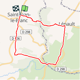
Trail Walking of 7.1 km to be discovered at Normandy, Calvados, Terres de Druance. This trail is proposed by gr1346.
Positioning
Country:
France
Region :
Normandy
Department/Province :
Calvados
Municipality :
Terres de Druance
Location:
Saint-Jean-le-Blanc
Start:(Dec)
Start:(UTM)
671859 ; 5422941 (30U) N.
Comments